NYC NJ Blizzard Warning: 12+ Inches of Snow Could Paralyze the Region
A powerful winter system is moving toward the Northeast, and forecasters say the NYC NJ blizzard warning could become a serious reality this weekend. Meteorologists are tracking a fast-developing coastal storm that may dump more than 12 inches of snow across parts of New York City and northern New Jersey. Heavy snowfall, fierce winds, and near-whiteout conditions could create dangerous travel and possible power outages.
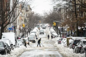
Residents across the tri-state area are already preparing. Grocery stores are seeing longer lines. Hardware shops report brisk sales of ice melt and shovels. The buzz is real because this storm has the ingredients for disruption. When snow combines with wind gusts above 35 mph, it can meet blizzard criteria. That means low visibility and hazardous road conditions for hours at a time.
The NYC NJ blizzard warning signals more than just snow. It points to intense weather that can impact daily life, transportation, and emergency services. Understanding what is coming helps you prepare wisely and stay safe.
NYC NJ Blizzard Warning: What the Latest Forecast Shows
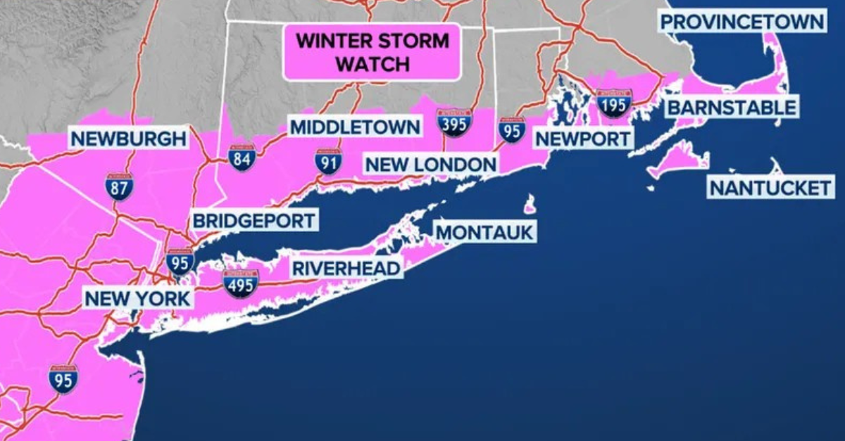
Forecasters say a coastal low-pressure system will strengthen rapidly as it moves northward. As colder air locks in, precipitation will fall mainly as snow across the region. Current projections show totals ranging from 8 to 14 inches, with locally higher amounts possible.
The heaviest snow is expected late Saturday into early Sunday. Snowfall rates could exceed one inch per hour at times. That intensity can overwhelm road crews quickly. Even treated roads may become slick.
Wind gusts may reach 40 mph along coastal areas. When strong winds mix with falling snow, blowing and drifting become major problems. Visibility may drop below a quarter mile, especially overnight. These are the classic ingredients of a blizzard.
However, small shifts in storm track could change totals slightly. Meteorologists stress that confidence is high for significant snowfall. Therefore, residents should monitor updates closely as the NYC NJ blizzard warning evolves.
How Much Snow Could NYC and NJ Actually See?
Snowfall totals vary depending on location. Coastal areas might see mixing at first, but colder air should dominate quickly. Inland communities are more likely to see consistent heavy snow.
Here is a general estimate:
|
Location |
Estimated Snowfall |
|
NYC Metro |
8–12 inches |
|
North Jersey |
10–14 inches |
|
Long Island |
6–10 inches |
|
Hudson Valley |
12+ inches |
Some neighborhoods could exceed these projections if snow bands stall overhead. Those narrow bands often produce intense snowfall for several hours. When that happens, totals can jump fast.
The NYC NJ blizzard warning does not guarantee exact numbers. Instead, it highlights the risk of heavy accumulation combined with strong winds. That combination creates the most disruption.
Travel Disruptions Under the NYC NJ Blizzard Warning
Travel may become extremely dangerous. Road crews will work around the clock, yet snowfall rates could outpace plowing efforts. Highways such as the New Jersey Turnpike and major parkways in New York may experience reduced visibility and slippery surfaces.
Airports including JFK, LaGuardia, and Newark Liberty could see delays or cancellations. Airlines often adjust schedules in advance to reduce congestion. If you have travel plans, checking with carriers early is wise.
Public transportation may also face slowdowns. Snow-covered tracks and icy switches can cause delays. Commuters should plan extra time and consider staying home if possible.
Under the NYC NJ blizzard warning, officials may issue travel advisories. Limiting unnecessary trips reduces accident risks and allows emergency vehicles to move more freely.
Potential Power Outages and Infrastructure Concerns
Heavy, wet snow combined with gusty winds can strain power lines. Tree branches coated in snow become heavier and more likely to snap. If wind gusts increase, scattered outages could occur.
Utility crews are preparing for rapid response. Still, restoration times may vary depending on conditions. Keeping phones charged and having flashlights ready is essential.
Apartment buildings in urban areas are less likely to experience extended outages. However, suburban and wooded communities face higher risks. The NYC NJ blizzard warning encourages residents to prepare for temporary service disruptions.
Simple preparations include:
- Charging electronic devices
- Stocking bottled water
- Keeping extra blankets available
- Checking backup heating options
These small steps make a big difference during winter storms.
How to Prepare Before the Snow Arrives
Preparation does not need to feel overwhelming. Start with the basics. Stock up on groceries for a few days. Make sure essential medications are filled. Check snow removal tools and fuel supplies.
Vehicle readiness also matters. Ensure tires have proper tread. Keep windshield washer fluid rated for freezing temperatures. Place a winter emergency kit in your car that includes:
- Flashlight
- Blanket
- Water
- Non-perishable snacks
- Ice scraper
The NYC NJ blizzard warning is a reminder to think ahead. Preparation reduces stress and keeps families safer.
What Makes This Storm Different?
Not every snowstorm earns blizzard status. The key factor is wind. Sustained winds or frequent gusts above 35 mph for several hours can create whiteout conditions. That is what meteorologists are watching closely.
Additionally, rapid intensification near the coast may increase snowfall rates. When storms strengthen quickly, they can surprise even experienced forecasters. The developing system shows signs of strong coastal energy.
The NYC NJ blizzard warning reflects the potential for intense snowfall combined with strong wind fields. If both elements align, impacts could rival some of the region’s notable winter storms.
When Will Conditions Improve?
Snow is expected to taper off by Sunday afternoon. However, cleanup may take longer. Plows will need time to clear secondary roads. Temperatures may remain below freezing, causing lingering icy patches.
Sunshine early next week should help gradual melting. Still, overnight refreezing may occur. Residents should remain cautious during the morning commute.
The NYC NJ blizzard warning may expire once snowfall ends and winds weaken. Yet safety remains important even after the storm passes.
Final Thoughts on the NYC NJ Blizzard Warning
The approaching storm has the potential to bring more than a foot of snow and strong winds to New York and New Jersey. While snowfall totals may shift slightly, confidence is growing that significant impacts are likely.
Preparation remains the best defense. Monitor local forecasts, limit travel during peak snowfall, and check on vulnerable neighbors. Winter storms test communities, but careful planning reduces risks.
The NYC NJ blizzard warning serves as an early alert. By staying informed and prepared, residents can weather the storm safely and confidently.